Kia ora everyone!
Welcome to Part Three of the Great Hitchhiking Adventure. Took a wee break from the roads and hit the trails for a four day trek on the famous Routeburn Track.

The Routeburn is one of the Department of Conservation (DOC) Great Walks, so it ensures the trail will be well-maintained and promises great views.
The full track runs nearly from Te Anau to Queenstown and can be started from either direction. We started at the south western trailhead, walking in the direction of Queenstown.

If you have access to a car (preferably which you aren't renting by the day), and know other trampers interested in the Routeburn, I'd recommend coordinating with them to park at opposite ends of the trail and hike the same days. You could even book a hut or campsite for the same night to meet up in the middle! No messy or expensive shuttles to rush to catch and tramping with friends -- what could be better?

Day One:


"Jeez guys, New Zealand really is breathtaking."
"Yeah, literally and metaphorically."

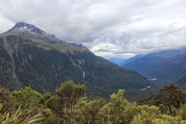

View at Lake Howden Hut. Luckily the rain started just as we got to our stopping place for the day.


Claire, Charlie, and I decided to make the little trip up to Key Summit, one of the excursions from the huts. Many people told us that it was one of the highlights of the tramp, and others make Key Summit a full daytrip. Couldn't help but snap a few shots of the beautiful "view" we had of Lake Marian.

Day Two:


The forecast for the entire four day trip looked horrible; so bad there were serious hazard warnings for trampers. This track confirmed my belief that it's basically impossible to predict the weather in Fiordland.


Yolo, I guess?


What was nice about short days like our second on the trail, which only took about four hours, was that it left plenty of time to explore/relax once we arrived at our stopping point. After we got to the campsite our second night, we got to explore the gorgeous Lake Mackenzie.


Climbing the vines that run along Split Rock, only a short walk from the campsite.
Day Three:

View of Lake Mackenzie from the trail above.


A little more than halfway on our longest day. Harris Saddle was a great lunch spot and a nice place to drop our packs and scramble up Conical Hill to the highest point on the track!

View of Harris Saddle Shelter from the track up Conical Hill.
The rest of the climb required a lot of focus (and often times both hands), so I didn't get too many shots showing the huge rocks we were climbing our way up.


One of my favorite parts of the whole track: SWING BRIDGES!

With worries about water and energy, Kim and Claire had continued walking the main track while Charlie and I made the lunchtime climb to the summit. It meant we arrived at our campsite around dark, but luckily the other two heeded the inclement weather reports and upgraded to the hut next to the campsite, meaning they were able to use the facilities to cook us dinner.

Charlie's awesome tent, pitched at the Routeburn Flats campsite.
Day Four:
I didn't actually snap any pictures on the last day; sometime early in the morning, the bad weather they had been predicting for days finally rolled in. Charlie and I woke up on our last morning smack dab in the middle of one of the most impressive storms I've ever heard. Thank god we had decided to pitch her tent (the rainfly on mine is a little challenged). We stayed entirely dry as we listened to the storm rage around us.
When it was time to pack up and head out, we dragged the whole tent, still pitched, under the treeline where there was a little more cover to put it away.
During the final walk out, less than three hours total, it absolutely dumped rain on us. We may as well have gone for a swim with all our gear for how dry we stayed.
Personally, I loved it. (Being from Oregon, I felt very at-home hiking in the rain.) Besides, what better day than the last to get rained on?
Once we arrived at the car park to wait for the shuttle that would be picking us up, we changed into whatever little had stayed dry in our packs and fired up our little cooker to heat up some hot cocoa and oatmeal. Not a bad way to wrap up an amazing four days.
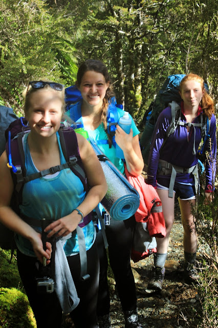
Time to meet the trampers! (aka a chance for me to brag about my awesome friends)

This is Kim, our resident "delicate flower." (Ironically, she's actually allergic to most flowers, as well as tree nuts, apples, and raw carrots.) Routeburn was actually Kim's first backpacking trip ever and she even planned the entire thing herself, from campsites to shuttles!

Charlie: Our scientist and outdoor-guru. Charlie is studying zoology (and, after spending a few months in NZ, is considering pursuing her new-found passion for moss). I think she's also half mountain goat. She's one of the quickest people I've ever seen on a mountain; if we hadn't booked a hut and two campsites, I bet Charlie would have done the whole Routeburn in a day.

This little ray of sunshine is basically our good luck charm. It's almost guaranteed that if Claire is around the weather will be stunning. Claire is studying creative writing and is one of the sweetest -- and most entertaining -- people I've ever met.
Up next: adventures in Queenstown and the Kepler Curse. Thanks for reading, everyone!
No comments:
Post a Comment